Trust Lands Use Plan
Pursuant to Senate Bill 507 (SB 507), the California State Lands Commission (State Lands) granted approximately 8,000 additional acres (7,900 additional acres of water area within San Diego Bay and approximately 100 acres of land) to the Port of San Diego on January 1, 2020. Pursuant to SB 507, the Port is preparing a Trust Lands Use Plan (TLUP) for the additional area now under the Port’s trust and will add it to the Port Master Plan via an amendment, bringing the newly granted areas into the Port’s coastal permitting jurisdiction. This plan will provide goals, policies, and information on allowable uses and activities within the planning area and must describe any proposed development, preservation, or other use of the trust lands.
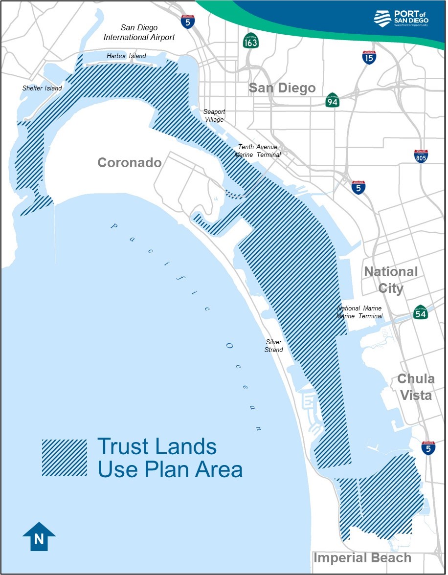
Image: the blue hatched area represents the area that will be covered by the Trust Lands Use Plan. It is mostly water area within the bay. No landside development will be contemplated in the Trust Lands Use Plan, apart from minimal recreational uses and environmental or habitat conservation uses. It is important that any expanded or new uses do not conflict with priority uses that already exist on and around the bay like water recreation, cargo and other large vessel movement via the federal navigation channel, commercial fishing, public safety, national security, environmental conservation, and more.
Final Draft TLUP and Mitigated Negative Declaration
November 2025
At the December 9, 2025 Board of Port Commissioners meeting, the Board will consider approving a Port Master Plan Amendment (PMPA) for the Final Draft TLUP and adopting the Mitigated Negative Declaration (MND) for the TLUP. Click on the links below for these documents as well as a tracked changes version of the Final Draft TLUP, which shows the text changes between the Revised Draft TLUP that was published in February 2025 and the Final Draft TLUP that is pending board approval on December 9.
Final Draft TLUP (WITH TRACKED CHANGES)
Mitigated Negative Declaration (MND) - COMING SOON
As part of the Port’s commitment to a transparent and public outreach process, the Port welcomes and encourages all feedback throughout the TLUP approval process. In addition to seeking public review, Port staff has met and will continue to meet with stakeholders to help identify current uses within the TLUP area that should be preserved, protected, and maintained; to proactively address potentially competing uses/activities; and to see where there may be opportunities to improve, enhance and/or expand some uses. It’s important that any expanded or new uses do not conflict with priority uses that already exist on and around the bay like water recreation, cargo and other large vessel movement via the federal navigation channel, commercial fishing, public safety, national security, environmental conservation, and more.
Revised Draft TLUP and Mitigated Negative Declaration
February 2025
The Port has prepared a Mitigated Negative Declaration (MND) for the TLUP, as well as a Revised Draft TLUP. The Draft MND and the Revised Draft TLUP were available for a 30-day public review period, which concluded at 5 p.m. on Thursday, March 27, 2025. The Port has also prepared a “tracked changes” version of the TLUP, which shows the text changes between the Draft TLUP and the Revised Draft TLUP. A physical copy of the Draft MND and Revised Draft TLUP are also available for public review during normal business hours at the San Diego Unified Port District Office of the District Clerk, 3165 Pacific Highway, San Diego, CA 92101-1128.
TLUP Discussion Draft & Draft TLUP
2023
On September 12, 2023 the Port of San Diego Board of Port Commissioners directed Port staff to submit the Draft Trust Lands Use Plan to State Lands and begin environmental review of the draft plan. In October 2023, Port staff presented and submitted the Draft TLUP to the California State Lands Commission, which satisfied a requirement of SB 507.
Draft TLUP (with tracked changes)
On July 21, 2023, the Port released a Discussion Draft of the TLUP for a 30-day public review period and received 22 comments. The Draft TLUP incorporates revisions based on comments received on the Discussion Draft.
Next Steps
- If the Final Draft TLUP is approved and the Board directs staff to move forward with the PMPA, staff will submit the required documentation to the Coastal Commission, which will begin the PMPA certification process.
- Once the PMPA is certified by the Coastal Commission, Port staff will submit the TLUP to State Lands for approval, as stipulated in SB 507. Port staff anticipates final approval of the TLUP in 2026.
- Port staff will continue to coordinate with State Lands throughout the TLUP process, as well as stakeholder engagement and public outreach.
Background
Since 1962, the Port has successfully managed and balanced a mix of coastal-dependent uses on and around San Diego Bay for the people of California while striking a balance that respects both local perspectives and broader statewide public interests. The Port does this in a manner that promotes commerce, navigation, recreation, fisheries, and environmental stewardship consistent with the Port Act, the Coastal Act, and the Public Trust Doctrine. Based on this history and expertise, State Lands recognized the Port is in the best position to manage and ensure efficient oversight of the additional area, which is often referred to as the “donut hole” because it is encircled by tidelands and submerged lands already under Port management. The newly granted areas begin from the mouth of San Diego Bay down to and including the San Diego Bay National Wildlife Refuge. (Note: The area granted to the Port comprises tidelands and submerged lands only, not the water column. The granted area also does not include submerged lands managed by the U.S. Navy.) Prior to SB 507, the Port managed 2,404 acres of tidelands and 3,677 acres of submerged tidelands. Including the newly granted area, the Port now manages more than 14,000 acres of tidelands and submerged lands in and around San Diego Bay and along the Imperial Beach coastline.